New Orleans: 1720-1850's
 Illustration 1: Map of New Orleans region 1720.
http://www.kidsmaps.com/geography/images/fullsized/lake-borgne.png
Illustration 1: Map of New Orleans region 1720.
http://www.kidsmaps.com/geography/images/fullsized/lake-borgne.png
Early Development and Planning:
Before the formal establishment of the crescent shaped parcel of land that would become modern day New Orleans' French Quarter, the local Native American tribes had made use of the strategic location for thousands of years. (Illustration 1) With the nearby access to the Gulf of Mexico, the mighty Mississippi and Lake Pontchartrain, this region of Louisiana was an important factor in the success of the first inhabitants. Financier John Law viewed this region as one that could restore the French economy as a lucrative trading corridor and convinced his friend Phillipe duc d' Orleans, regent of France, to have the french Governor of Louisiana Jean-Baptiste Le Moyne de Bienville establish "La Nouvelle-Orléans", or New Orleans, as the capitol of the colony. He also allowed Law control of all commerce in Louisiana. New Orleans was meant to be the headquarters of a thriving trade company. By 1720, New Orleans “boasts houses for governor and director, company store, hospital, over 100 employees and 250 concession holders ready to work their land. But settlement is haphazardly laid out; disease takes it toll; and commercial effort struggles financially”.[i]Despite the disadvantages of choosing this particular flood prone geographical site with its pesky mosquitoes and muddy terrain, the positive attributes of a deep port and favorable shipping routes via the Mississippi made it the wisest choice for the Louisiana capitol at the time. Through the use of land grants Bienville facilitated development and willing settlers undertook the challenges of building in the region's unforgiving muddy terrain.
Before the formal establishment of the crescent shaped parcel of land that would become modern day New Orleans' French Quarter, the local Native American tribes had made use of the strategic location for thousands of years. (Illustration 1) With the nearby access to the Gulf of Mexico, the mighty Mississippi and Lake Pontchartrain, this region of Louisiana was an important factor in the success of the first inhabitants. Financier John Law viewed this region as one that could restore the French economy as a lucrative trading corridor and convinced his friend Phillipe duc d' Orleans, regent of France, to have the french Governor of Louisiana Jean-Baptiste Le Moyne de Bienville establish "La Nouvelle-Orléans", or New Orleans, as the capitol of the colony. He also allowed Law control of all commerce in Louisiana. New Orleans was meant to be the headquarters of a thriving trade company. By 1720, New Orleans “boasts houses for governor and director, company store, hospital, over 100 employees and 250 concession holders ready to work their land. But settlement is haphazardly laid out; disease takes it toll; and commercial effort struggles financially”.[i]Despite the disadvantages of choosing this particular flood prone geographical site with its pesky mosquitoes and muddy terrain, the positive attributes of a deep port and favorable shipping routes via the Mississippi made it the wisest choice for the Louisiana capitol at the time. Through the use of land grants Bienville facilitated development and willing settlers undertook the challenges of building in the region's unforgiving muddy terrain.
 Illustration 2: "Veüe et Perspective de la Nouvelle Orleans" (View & Perspective of New Orleans), 1726 by Jean-Pierre Lassus http://upload.wikimedia.org/wikipedia/commons/0/0c/NouvelleOrleans1726LassusA.jpg
Sustainable Planning
The notion of sustainability is a modern concept, but the idea of conserving limited resources was prevalent in the early planning of New Orleans. The extent of the efforts to preserve the natural resources are limited, but it is clear that the early settlers of the region sought some preservation. In the historical record there are instances of the regional leadership urging conservation. “'We [urge that] individuals preserve woods on their land', wrote Governor Perier in 1729”. The Governor further urged settlers to that 1/3 of the trees on their lands should remain uncut. Resolutions were adopted during the same era by early leaders that required the planting of mulberry trees and forbid destroying any that already existed.i
Land Use and Urban Design
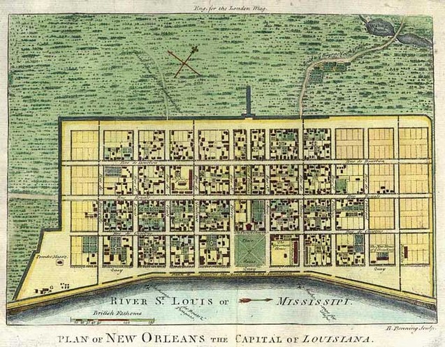
1761 plan for New Orleans based on de La Tour's 1720 survey. http://www.raremaps.com/maps/large/7164.jpg
Engineer Pierre Le Blond de La Tour surveyed the New Orleans region and, along with his assistant Adrien de Pauge, drew first grid for the city.[i]The pattern followed those common to the Ancien Régime system of colonial France in the establishment of new settlements. It was a geometric 14 block grid with a town square and a main avenue that ran directly up the city (Illustration 3). The grid designed by de La Tour remains largely unchanged and has become known as New Orleans' famous French Quarter.
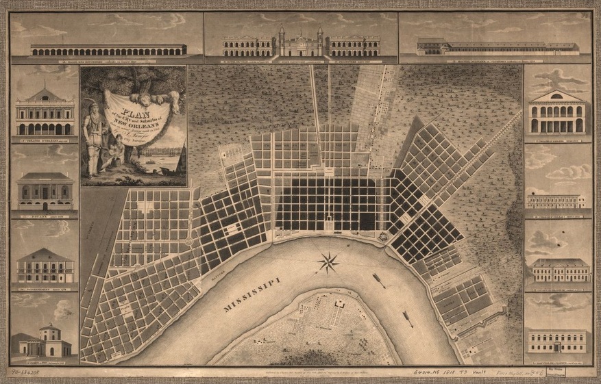
Illustration 4: Plan of the city and suburbs of New Orleans : from an actual survey made in 1815 http://memory.loc.gov/cgi-bin/image-services/jp2.py?data=/home/www/data/gmd/gmd401/g4014/g4014n/ct000684.jp2&res=3
A century later, development of the surrounding suburbs evolved in a slightly more organic way, but still retaining a geometric grid pattern emanating out from the original.(Illustration 4) At the end of the central avenue was space dedicated to church overlooking a public square. The first church built on the site was far more modest a structure than the one that replaced it after a fire in 1788. (Illustration 5, 6) A massive remodel commenced in 1844, leading to the St. Louis Cathedral that stands at the site today.

Illustration 5: The first church built on the site of St. Louis Cathedral in 1727
http://stlouiscathedral.org/saintlouisimageold1.jpg
|

llustration 6: Th St. Louis Cathedral completed in 1789
http://stlouiscathedral.org/saintlouisimageold3.jpg
|

Image 1: St Louis Cathedral
http://stlouiscathedral.org/Cathedral_wpath_lores.jpg

Illustration 7: The Old Cabildo in 1794
http://www.hnoc.org/vcs/images/covers/C_2_043_015.jpg
Space for government use also occupied the area around the central public square that was called Place d'Armes, later renamed Jackson Square in honor of Andrew Jackson's victory at the Battle of New Orleans in 1815. During Spanish rule, the Cabildo was built as the headquarters of the municipal government. The original structure was destroyed in the devastating fire of 1788, but was rebuilt in 1799 and remains today. (Illustration 7)

Illustration 8: St. Louis Cathedral flanked by the Cabildo on the left
and Prebystere on the right, 1845.
http://www.hnoc.org/vcs/images/covers/C024n1361.jpg
The
area surrounding the public square was the center of community life
and the structures in that space fulfilled the needs of the citizens
in terms of church, commerce and government. “Herbert Ashbury
provides a description of New Orleans about 1803 that is reasonably
accurate: '...All the public buildings, of which the Cabildo, the
Arsenal and the French Market remain today substantially as they were
then faced the [Plaza d'Armes], which was no more than a grass plot
barren of shrubbery.'”i
(Illustration 8)
Despite the pervasive cultural and aesthetic association between New Orleans and France, it lasted less than half a century.In 1762 France transferred rule of Louisiana to the Spaniards. The French Quarter we see today is predominately influenced by the designs implemented under Spanish authority. The aforementioned wooden structures built by the French were destroyed by two large fires near the turn of the century. The buildings that replaced them were architecturally Spanish and using stucco exteriors, as opposed to wood shingles, to protect from future fire disasters.ii Historian Sally Reeves addresses the mix of influences stating, “The city plan, the central square overlooked by church and state, French arpents, city lots, faubourgs, heavy trusses, Creole cottages, the old convent, and Charity Hospital came from the French side. But streetscapes full of repeating arches, Arabesque ironwork, covered passageways, and the still-alluring sense of guarded privacy came from His Catholic Majesty of Spain, not His Christian Majesty of France.”iii
Despite the pervasive cultural and aesthetic association between New Orleans and France, it lasted less than half a century.In 1762 France transferred rule of Louisiana to the Spaniards. The French Quarter we see today is predominately influenced by the designs implemented under Spanish authority. The aforementioned wooden structures built by the French were destroyed by two large fires near the turn of the century. The buildings that replaced them were architecturally Spanish and using stucco exteriors, as opposed to wood shingles, to protect from future fire disasters.ii Historian Sally Reeves addresses the mix of influences stating, “The city plan, the central square overlooked by church and state, French arpents, city lots, faubourgs, heavy trusses, Creole cottages, the old convent, and Charity Hospital came from the French side. But streetscapes full of repeating arches, Arabesque ironwork, covered passageways, and the still-alluring sense of guarded privacy came from His Catholic Majesty of Spain, not His Christian Majesty of France.”iii
Housing

Image 2: 1751 Old Ursuline Convent
http://lcweb2.loc.gov/service/pnp/highsm/12600/12641r.jpg
An Ursuline nun who arrived in New Orleans in 1927 described what she saw in her new hometown: “'Our city is very beautiful, well constructed and regularly built[,] as I saw of it on the day of our arrival...The streets seem wide and straight; the principal one [now Decatur Street] is almost a league long. The houses are built with wooded-front and mortar, whitewashes, wainscoted and latticed. The houses are covered with shingles which are tin boards in the shape of slate, [with] all the appearance and beauty of slate. It suffices to tell you that there is sung publicly a song, in which it is said that this city has a fine as appearance as the City of Paris.'”[1]The description of the simple early homes of the settlement is a contrast to what housing eventually evolved into over the next century as New Orleans grew. By 1803, New Orleans had approximately 10,000 inhabitants of extraordinarily diverse backgrounds. The mix of French, Spanish, African, Caribbean, and Native American cultures influenced the style of dwellings and eclectic architecture that make New Orleans unique to this day.[4]
Unfortunately, the only surviving residence in the French Quarter from French colonial rule is the Ursuline Convent and the only example still standing after fires destroyed the city in 1788 and 1794.[6] (Image 2) One surviving home built in 1788 that survived the subsequent fire is said to be typical of the prosperous white Creole settlers who had found success in the early formation of the city. The French Quarter home is known as “Madame John's Legacy” and it is a sound example of the homes that were in existence during the French Colonial era.[7](Image 3)
Unfortunately, the only surviving residence in the French Quarter from French colonial rule is the Ursuline Convent and the only example still standing after fires destroyed the city in 1788 and 1794.[6] (Image 2) One surviving home built in 1788 that survived the subsequent fire is said to be typical of the prosperous white Creole settlers who had found success in the early formation of the city. The French Quarter home is known as “Madame John's Legacy” and it is a sound example of the homes that were in existence during the French Colonial era.[7](Image 3)
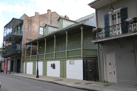
Image 3 1788 Madame John's Legacy
http://www.neworleansonline.com/images/slideshows/listings/1268/05.jpg
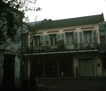
Image 4 1795 Bosque House
Tulane University Virtual Archive
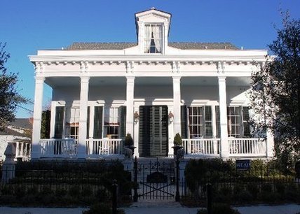
As the Spanish came to power in the later part of the 18th century, the structures became more lavish. Tile and brick replaced the siding and shingles. Patios and courtyards became the norm for upscale residences. [8] (Image 4, 5)
|
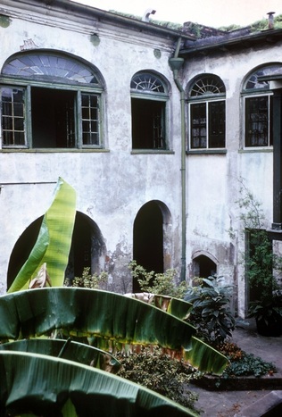
Image 5 Bosque House Courtyard
Tulane University Virtual Archive
|
There were several common house types from the late 18th to the mid 19th centuries that served as the residences for most inhabitants of New Orleans:
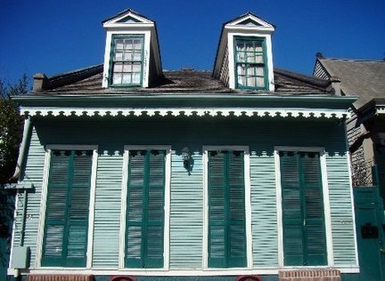
- Creole Cottage: Small homes with a pitched side gabled roof using “brick between post” or masonry for construction. Common features include sets of wooden french doors and narrow windows. There are Spanish and French influences in their design.[9]
- Shotgun House: Long narrow homes that are a succession of rooms with no hall. One could theoretically shoot a shotgun through the front door and out the back passing each room. They are influenced by the free African population that was prevalent in New Orleans. [10]
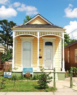
- Central Hall Cottage: A rectangular home with a front porch that runs across the facade. It has a central hall down the middle of the home that offers access to the adjacent rooms. These homes were influenced by the Caribbean immigrants of New Orleans. [9]
- Townhome: A two story narrow home with a hall that runs the length of the dwelling. The early New Orleans version has Creole attributes with features like french doors, narrow windows, porches and balconies that run the length of the facade.[9]
Creole Cottage
http://media.nola.com/home_impact/photo/01-cover-creole-cottagejpg-34e924f869121885.jpg
|
Shotgun House http://media.nola.com/home_impact/photo/01-cover-shotgun-singlejpg-92b4f7fbf0259a87.jpg
|

Townhome http://media.nola.com/home_impact/photo/01-cover-townhousejpg-6888618cad07c616.jpg
|
Central Hall Cottage
http://media.nola.com/home_impact/photo/01-cover-centerhalljpg-51c645b70087d754_large.jpg
|
Transportation
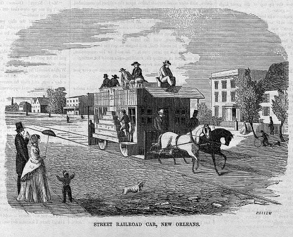
http://upload.wikimedia.org/wikipedia/commons/3/3c/Street_Railroad_Car_New_Orleans_1855_Bellew.jpg
Much of the development that was envisioned by the earlier fathers of the city; Bienville, Law and de La Tour, would not be realized for decades after the official establishment of New Orleans. The new settlement was plagued by disease, floods and fires. The primary reason for choosing the difficult terrain was that negative attributes could be overcome by the positive gains made by using the numerous waterways that fed into the Mississippi. These routes offered far more ease of access to the gulf waters than any other possible location in the Louisiana colony. It was the water that would bring both prosperity and despair to New Orleans throughout the next three centuries. [11] New Orleans emerged as the fourth largest city in 1840 with the continuance of people migration from France, Haiti, and free slaves. With such a large population, innovations in transportation were in high demand. New Orleans is geographically positioned between the Mississippi River and the Gulf of Mexico making it a popular shipping port. To put into perspective the demand on New Orleans as a shipping port, in 1812, the first steamship left the Mississippi River carrying 67,560 tons. By 1840, there were 1,573 steamships that entered the New Orleans Port that carried on average 537,000 tons [11]. Because New Orleans was such a popular shipping port, it also caused much river traffic in the Eerie Canal. Therefore, another advancement was the Pontchartrain Railroad that connected New Orleans to Lake Pontchartrain. The success of this 4.5-mile railroad was questionable, as the builders in the 1830’s had never built a railroad before. The train was initially pulled by horses, and later, a steam engine car was imported from England [11]. The second greatest railway to be built was the St. Charles Avenue Line, which connected New Orleans with surrounding neighborhoods and was the first railroad to use locomotives that did not involve pulling by a horse.
1. Campanella, Richard. Bienville's Dilemma: A Historical Geography of New Orleans. Lafayette: Center for Louisiana Studies, University of Louisiana at Lafayette, 2008. Read.Amazon.com. Web. 28 July 2013.
2. "The French Period –." Iadb.org. Cultural Center of the Inter-American Development Bank, n.d. Web. 26 July 2013. <http://www.iadb.org/exr/cultural/catalogues/orleans/french_period.html>.
3. "History of the St. Louis Cathedral." Stlouiscathedral.org. Archdiocese of New Orleans, n.d. Web. 30 July 2013. <http://stlouiscathedral.org/early_history.html>.
4. Din, Gilbert C., and John E. Harkins. "Preface." The New Orleans Cabildo: Colonial Louisiana's First City Government, 1769-1803. Baton Rouge: Louisiana State UP, 1996. 4. Print.
5. "French Quarter S'il Vous Plait." TNEMEC.com. Tnemec, n.d. Web. 25 July 2013. <http://www.tnemec.com/news/FrenchQuarter.aspx>.
6. Irvin, Hilary. "Ursuline Convent." KnowLA Encyclopedia of Louisiana. Ed. David Johnson. Louisiana Endowment for the Humanities, 17 Jun. 2011. Web. 30 Jul. 2013.
7. Irvin, Hilary. "Madame John’s Legacy." KnowLA Encyclopedia of Louisiana. Ed. David Johnson. Louisiana Endowment for the Humanities, 1 Oct. 2012. Web. 30 Jul. 2013.
8. Arthur, Stanley Clisby., and Susan Cole. Doré. "Chapter 1." Old New Orleans. Gretna, LA: Pelican Pub., 1990. 15-16. Print.
9. United States. City of New Orleans. Historic Landmarks Division. Building Types and Architectural Styles. By Dominique M. Hawkins and Catherine E. Barrier. Department of the Interior, National Park Service, May 2011. Web. 24 July 2013. <http://www.nola.gov/nola/media/HDLC/Guidelines/03-TypesStyles.pdf> .
10. Vlach, John Michael. "The Shotgun House: An African Architectural Legacy." Pioneer America 8.1 (1976): 47-56. Print.
11.Weingroff, Richard. "The Rambler's History of New Orleans -Highway History - FHWA." Origins of New Orleans. U.S. Department of Transportation, 07 Apr. 2011. Web. 14 July 2013. <http://www.fhwa.dot.gov/infrastructure/neworleansrambler.cfm>
12. "Rail Transit Authority History." Norta.com. New Orleans Regional Transit Authority, n.d. Web. 30 July 2013. <http://www.norta.com/about/History/index.html>
