New Orleans: 1850's-1900's
Sustainable Development:
 http://www.moveinandout.com/images/city_guide_images/new_orleans2.jpg
Long Struggle with Levees
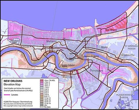
The New Orleans land is not exactly the safest region to build a city. The land itself is a natural levee that was a result of soil deposits from the Mississippi River over time. Though the land is not strategic safety-wise, it serves as a beneficial region of transportation. Geographically, three bodies of water surround New Orleans: Gulf of Mexico, Mississippi River, and Lake Pontchartrain, making it very susceptible to periodic floods and hurricanes. As the elevation map shown below in Figure 1.1, a vast majority of New Orleans sits below sea level which creates a high demand for efficient drainage system and levees to protect the city from natural disaster. The first drainage systems were built in 1721 and the first four-foot high levee was built the following year. The efforts at this point were still slim, and New Orleans stiff suffered from floods that would last for an estimated month. In 1828, another flood hit New Orleans recording the highest water level in time. This incident became a wake up call to the U.S. government to demand tax for maintenance of levies and to place laws on the dimensions of the levees. In fact, most of the buildings in New Orleans during the 19th century were built one foot above the grounds due to certainty of flooding. Efforts continued to be weak and between 1849 and 1874, and a total of four breaches occurred in the Mississippi River due to inefficient levees. Each breach sent a flood towards New Orleans at a rate of 150,000 cubic feet per second. [3] Though it seems that recovery after each flood, the New Orleans government would increase maintenance of these issues, the worst flood of all time came in 1882 where 200 breaches occurred along the Mississippi River leaving New Orleans flooded for 91 days. During these floods, poverty, famine, and evacuation occurred. In 1893, the Sewerage and Water Board of New Orleans was funded to maintain drainage of the city and construct modern sewage and a tap water system. [4]
The New Orleans land is not exactly the safest region to build a city. The land itself is a natural levee that was a result of soil deposits from the Mississippi River over time. Though the land is not strategic safety-wise, it serves as a beneficial region of transportation. Geographically, three bodies of water surround New Orleans: Gulf of Mexico, Mississippi River, and Lake Pontchartrain, making it very susceptible to periodic floods and hurricanes. As the elevation map shown below in Figure 1.1, a vast majority of New Orleans sits below sea level which creates a high demand for efficient drainage system and levees to protect the city from natural disaster. The first drainage systems were built in 1721 and the first four-foot high levee was built the following year. The efforts at this point were still slim, and New Orleans stiff suffered from floods that would last for an estimated month. In 1828, another flood hit New Orleans recording the highest water level in time. This incident became a wake up call to the U.S. government to demand tax for maintenance of levies and to place laws on the dimensions of the levees. In fact, most of the buildings in New Orleans during the 19th century were built one foot above the grounds due to certainty of flooding. Efforts continued to be weak and between 1849 and 1874, and a total of four breaches occurred in the Mississippi River due to inefficient levees. Each breach sent a flood towards New Orleans at a rate of 150,000 cubic feet per second. [3] Though it seems that recovery after each flood, the New Orleans government would increase maintenance of these issues, the worst flood of all time came in 1882 where 200 breaches occurred along the Mississippi River leaving New Orleans flooded for 91 days. During these floods, poverty, famine, and evacuation occurred. In 1893, the Sewerage and Water Board of New Orleans was funded to maintain drainage of the city and construct modern sewage and a tap water system. [4]
Urban Planning / Land Use: City Beautifying Movement
Initiation of More Organization:
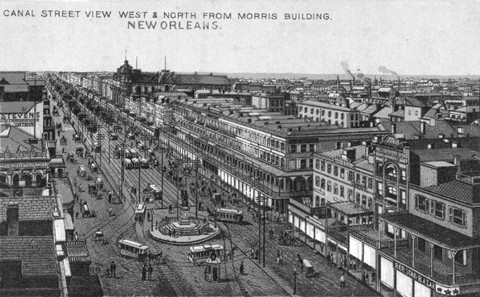
As New Orleans attracted many visitors and an increasing amount of immigrants, thoughts about beautifying the city emerged. The movement began with Canal Street, which was New Orlean’s main street that had the attractions for tourists and people searching for entertainment. In 1854, Rezin Shephard, a New Orleans banker, offered councilman Alexander Gordon a donation $150,000 under the conditions that the street will be paved with granite blocks across its entire width, and that the squares would have iron railings with trees organized landscape. It is observed here that streets in New Orleans are widening and becoming more organized. In Rezin Shephards’s letter, he writes “the same always to be kept in good order; the sidewalks not to exceed 11 feet in width, except between Levee and Camp street; that all projections over them shall be uniform, to correspond with those on Touro Row; and the present ordinances relative to the encumberments on the sidewalks be enforced” [5]. Although the ambitions for the movement were present, the Civil War in 1861 prevented the construction to take place. Any little work that was put into remodeling the street was stopped.
As New Orleans attracted many visitors and an increasing amount of immigrants, thoughts about beautifying the city emerged. The movement began with Canal Street, which was New Orlean’s main street that had the attractions for tourists and people searching for entertainment. In 1854, Rezin Shephard, a New Orleans banker, offered councilman Alexander Gordon a donation $150,000 under the conditions that the street will be paved with granite blocks across its entire width, and that the squares would have iron railings with trees organized landscape. It is observed here that streets in New Orleans are widening and becoming more organized. In Rezin Shephards’s letter, he writes “the same always to be kept in good order; the sidewalks not to exceed 11 feet in width, except between Levee and Camp street; that all projections over them shall be uniform, to correspond with those on Touro Row; and the present ordinances relative to the encumberments on the sidewalks be enforced” [5]. Although the ambitions for the movement were present, the Civil War in 1861 prevented the construction to take place. Any little work that was put into remodeling the street was stopped.
Public Space: Lafayette Square
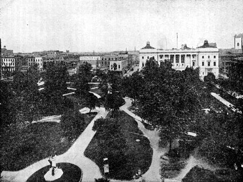
An example of public space that was renovated during this movement was Lafayette Square. Lafayette Square was initially a private area gated by high iron fences and was only open from 9 A.M. to 9 P.M [5]. However, during World War I, the federal government had a high demand for steel iron and therefore, the surrounding gates of Lafayette Square had to be removed [7]. Lafayette Square was the center of the Lafayette Square Historic District where paved pathways lead to different streets. In addition, Lafayette Square was careful arranged in that one side of the square was the financial district with tall buildings, high rise offices, and banks. The other three sides of the square had the federal institutions that included the court, city hall, and the Hale Boggs Federal Office Building [7]. In 1853, Gallier Hall (former city hall) was built across the street in a neoclassical style. To embellish the area, the bronze statues were arranged in the East/West axis of the square, which included a statue of Ben Franklin in 1872, John McDonogh in 1897, and Henry Clay in 1900 [6]. Lafayette Square serves a valuable purpose in the heart of New Orleans as it a place of sociability, attracts tourists, has live entertainment, and is very accessible.
An example of public space that was renovated during this movement was Lafayette Square. Lafayette Square was initially a private area gated by high iron fences and was only open from 9 A.M. to 9 P.M [5]. However, during World War I, the federal government had a high demand for steel iron and therefore, the surrounding gates of Lafayette Square had to be removed [7]. Lafayette Square was the center of the Lafayette Square Historic District where paved pathways lead to different streets. In addition, Lafayette Square was careful arranged in that one side of the square was the financial district with tall buildings, high rise offices, and banks. The other three sides of the square had the federal institutions that included the court, city hall, and the Hale Boggs Federal Office Building [7]. In 1853, Gallier Hall (former city hall) was built across the street in a neoclassical style. To embellish the area, the bronze statues were arranged in the East/West axis of the square, which included a statue of Ben Franklin in 1872, John McDonogh in 1897, and Henry Clay in 1900 [6]. Lafayette Square serves a valuable purpose in the heart of New Orleans as it a place of sociability, attracts tourists, has live entertainment, and is very accessible.
Public Parks:
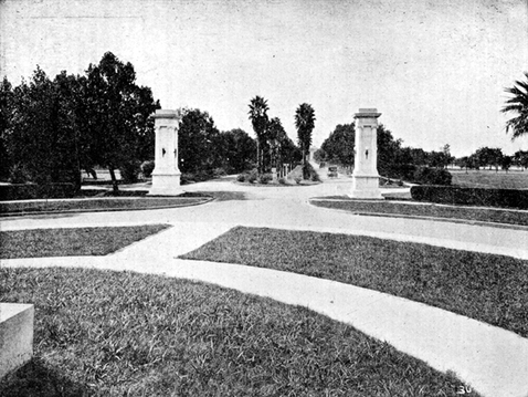
New Orleans also has two major city parks in opposite ends of the city to provide space for leisure activity, entertainment, social gatherings, and relaxation. The first park called Audobon was a 6-mile park located in uptown New Orleans and was sold to the city in 1871 and in 1879, it was called “New City Park”. For the early years that it was purchased, little renovation had been done to the park. However, in 1884, the World’s Cotton Centennial Exposition was hosted near the proximity of the park. Since this World’s exposition lures thousands of tourists and immigrants, it was an opportunity for New Orleans to show the world that it was a great city to live in and be a part of. Therefore during the construction of the World Exposition, elaborate plans for Audobon as an urban park were being drawn by landscape designer, John Charles Olmsted whose family was also famous for designing New York City’s central park. Landscape renovations to the park included a zoo and a flight cage by the turn of the century. The second historic urban park is City Park and is the sixth largest park in the U.S. The land was given to New Orleans city in 1850 by John McDonogh and the land was not improved until 1896. In 1898, George H. Grandjean (park board engineer) created an elaborate plan to beautify this city park. Much of the plan did not receive funding until the 1930’s.
New Orleans also has two major city parks in opposite ends of the city to provide space for leisure activity, entertainment, social gatherings, and relaxation. The first park called Audobon was a 6-mile park located in uptown New Orleans and was sold to the city in 1871 and in 1879, it was called “New City Park”. For the early years that it was purchased, little renovation had been done to the park. However, in 1884, the World’s Cotton Centennial Exposition was hosted near the proximity of the park. Since this World’s exposition lures thousands of tourists and immigrants, it was an opportunity for New Orleans to show the world that it was a great city to live in and be a part of. Therefore during the construction of the World Exposition, elaborate plans for Audobon as an urban park were being drawn by landscape designer, John Charles Olmsted whose family was also famous for designing New York City’s central park. Landscape renovations to the park included a zoo and a flight cage by the turn of the century. The second historic urban park is City Park and is the sixth largest park in the U.S. The land was given to New Orleans city in 1850 by John McDonogh and the land was not improved until 1896. In 1898, George H. Grandjean (park board engineer) created an elaborate plan to beautify this city park. Much of the plan did not receive funding until the 1930’s.
Renown French Opera House:
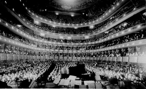
One of New Orleans most famous architectural buildings is the French Opera House located on the corners of Toulouse and Bourbon Street in the French Quarter, which had its grand opening in December 1, 1859. The building was designed by architect James Gallier, Jr. and had four tiers of horseshoe-shaped balconies, which held over 1,800 seats [11]. In addition, the French Opera House was the tallest building in the French Quarters with an 80-foot high ceiling. Not only was the building admired for it’s French architecture, but it was the heart of the French quarter and was the center for Creole society. In addition, it brought in many famous composers to perform such as Rossini, Verdi, Bellini, and Meyerbeer. In 1919, a massive fire burned down the French Opera House which motivated a New Orleans’ Times-Picayune editor to write, “the heart of the old French Quarter has stopped beating.” [11]
One of New Orleans most famous architectural buildings is the French Opera House located on the corners of Toulouse and Bourbon Street in the French Quarter, which had its grand opening in December 1, 1859. The building was designed by architect James Gallier, Jr. and had four tiers of horseshoe-shaped balconies, which held over 1,800 seats [11]. In addition, the French Opera House was the tallest building in the French Quarters with an 80-foot high ceiling. Not only was the building admired for it’s French architecture, but it was the heart of the French quarter and was the center for Creole society. In addition, it brought in many famous composers to perform such as Rossini, Verdi, Bellini, and Meyerbeer. In 1919, a massive fire burned down the French Opera House which motivated a New Orleans’ Times-Picayune editor to write, “the heart of the old French Quarter has stopped beating.” [11]
New Orlean’s Hosts the 100th Annual World Exposition:
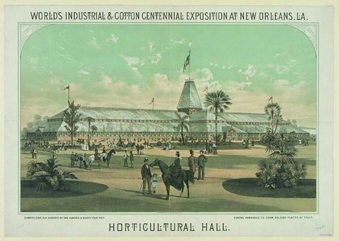
In 1882, the National Cotton Planters Association wanted to commemorate the 100th anniversary of the U.S.’ cotton industry and therefore nominated New Orleans as hosts. Historically, a third of the nation’s cotton had been produced from New Orleans and it was the area of cotton exchange, therefore, hosting the exposition at this location was a prime idea. The city of New Orleans widely accepted as it was an opportunity for them to advertise the city at the end of the reconstruction era. In 1884, construction of the World Exposition began at Audubon Park by 1885, the city had attracted 1 million visitors and about 36,000 afterwards for mardi gras. Notable buildings at this Worlds Exposition included the largest building in the nation during 1884 (33 acres) that displayed 5000 electric lights, Horticultural Hall (the largest greenhouse Figure 3.3), and the Octagonal Building (Mexican Exhibition) [8]. Unfortunately, New Orleans suffered from debt after the fair closed even though it attracted so many visitors because many scandals happened during construction of the fair. The largest scandal example was that state treasurer, Edward Burke, left the country with $1,777,000 of the fair’s budget during the time that he was supposed to be managing funds for the fair [8].
In 1882, the National Cotton Planters Association wanted to commemorate the 100th anniversary of the U.S.’ cotton industry and therefore nominated New Orleans as hosts. Historically, a third of the nation’s cotton had been produced from New Orleans and it was the area of cotton exchange, therefore, hosting the exposition at this location was a prime idea. The city of New Orleans widely accepted as it was an opportunity for them to advertise the city at the end of the reconstruction era. In 1884, construction of the World Exposition began at Audubon Park by 1885, the city had attracted 1 million visitors and about 36,000 afterwards for mardi gras. Notable buildings at this Worlds Exposition included the largest building in the nation during 1884 (33 acres) that displayed 5000 electric lights, Horticultural Hall (the largest greenhouse Figure 3.3), and the Octagonal Building (Mexican Exhibition) [8]. Unfortunately, New Orleans suffered from debt after the fair closed even though it attracted so many visitors because many scandals happened during construction of the fair. The largest scandal example was that state treasurer, Edward Burke, left the country with $1,777,000 of the fair’s budget during the time that he was supposed to be managing funds for the fair [8].
Housing:
 http://www.tinyhousedesign.com/wp-content/uploads/2008/10/shotgun-house-photo.jpg
Affordable Housing
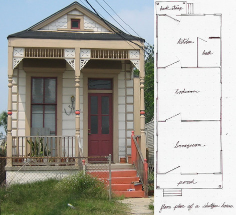
A popular form of housing that emerged in the later half of the 19th century of New Orleans were “shotgun” style homes. These houses have distinct features such as: rectangular and one bedroom wide, three bedrooms deep, no hallways or closets, small porches, built of raise brick, and the roof is support by columns. The various styles of Shotgun homes include the single of double shotgun, the camelback, and the sidehall cottage. The camelback is unique in that it has a second story to increase living space in a dense city area [10]. Shotgun houses were popular in the South and had a mixture of West African and West Indian Styles. This is due to the fact that similar housing architecture has been found in West Africa, Haiti, and the Dominican Republic [9]. The emergence of shotgun houses remain uncertain, but historians believe the design was brought from Haiti since the population of New Orleans in the 19th century had 1/3 whites, 1/3 slaves, and 1/3 free slaves. The free slaves from Haiti were the builders of these new neighborhoods [9]. Although these homes were extremely compact, they were beneficial because they were built near the city of New Orleans where transportation was still weak, which made it easier for people to move around. In addition, these homes were inexpensive to build and made affordable to the middle and working class [10]. Unfortunately, today, it has become the symbol of poverty.
A popular form of housing that emerged in the later half of the 19th century of New Orleans were “shotgun” style homes. These houses have distinct features such as: rectangular and one bedroom wide, three bedrooms deep, no hallways or closets, small porches, built of raise brick, and the roof is support by columns. The various styles of Shotgun homes include the single of double shotgun, the camelback, and the sidehall cottage. The camelback is unique in that it has a second story to increase living space in a dense city area [10]. Shotgun houses were popular in the South and had a mixture of West African and West Indian Styles. This is due to the fact that similar housing architecture has been found in West Africa, Haiti, and the Dominican Republic [9]. The emergence of shotgun houses remain uncertain, but historians believe the design was brought from Haiti since the population of New Orleans in the 19th century had 1/3 whites, 1/3 slaves, and 1/3 free slaves. The free slaves from Haiti were the builders of these new neighborhoods [9]. Although these homes were extremely compact, they were beneficial because they were built near the city of New Orleans where transportation was still weak, which made it easier for people to move around. In addition, these homes were inexpensive to build and made affordable to the middle and working class [10]. Unfortunately, today, it has become the symbol of poverty.
The Civil War: Battle of New Orleans
 http://www.billiesilvey.com/Battle-of-New-Orleans.jpg
The Battle of New Orleans occurred on August 24-25, 1862 and was lead by Admiral David G. Farragut. Flag Officer David G. Farragut lead his 43 ships towards the Mississippi River by New Orleans and fought to get past forts Jackson and St. Phillips. After five nights of firing to get past Fort Jackson, Farragut was able to get 13 ships through and only loss 37 lives whereas fighting along the Mississippi River cost Confederate General Lovell 782 lives, along with 6000 captured [3]. Luckily, because the Battle of New Orleans was not much of a land battle, urban buildings were spared the damage and most remained.
Transportation

Mississippi Bridge
During the civil war, New Orleans was under the Union Rule in 1862 and reconstruction of the city did not continue until 1877. Post Civil War innovations included the 1870’s Mississippi River Bridge (highly complex steel bridge) designed by Captain James B. Eads and jetties that deepened the channel of the Mississippi River which mitigated the New Orleans’ Port’s potential. Such improvements to the waterways in the later half of the 19th century brought about the heyday of the iconic Mississippi Steamboat. These vessels cut travel time significantly over land routes. Luxury “Showboats” carried New Orleans travelers to surrounding states in high style. Unfortunately, the steam technology was dangerous and explosions were common. Rail travel became the safer, more timely mode of long distance travel by the early 1900's. [12]
For the everyday transportation needs of the 19th century New Orleans citizen the streetcar was the primary means of getting around the expanding city. There were train lines that ran from the core of the city to the outer areas and Lake Pontchartrain, but as the city became more dense, the use of steam powered locomotives fell out of favor. The noise and danger led to experimentation with different modes of powering a light rail system until they were finally electrified in 1891. This was the factor that allowed for expansion of the system and an increase in popular use by the people of New Orleans.[13]
For the everyday transportation needs of the 19th century New Orleans citizen the streetcar was the primary means of getting around the expanding city. There were train lines that ran from the core of the city to the outer areas and Lake Pontchartrain, but as the city became more dense, the use of steam powered locomotives fell out of favor. The noise and danger led to experimentation with different modes of powering a light rail system until they were finally electrified in 1891. This was the factor that allowed for expansion of the system and an increase in popular use by the people of New Orleans.[13]
Footnotes:
1. Weingroff, Richard. "The Rambler's History of New Orleans -Highway History - FHWA." Origins of New Orleans. U.S. Department of Transportation, 07 Apr. 2011. Web. 14 July 2013. <http://www.fhwa.dot.gov/infrastructure/neworleansrambler.cfm>
2. "Battle of New Orleans". Encyclopædia Britannica. Encyclopædia Britannica Online.
Encyclopædia Britannica Inc., 2013. Web. 14 Jul. 2013
<http://www.britannica.com/EBchecked/topic/411915/Battle-of-New-Orleans>.
3. NOVA. "A 300 Year Struggle." PBS. PBS, 01 Nov. 2005. Web. 16 July 2013. <http://www.pbs.org/wgbh/nova/orleans/struggle.html>.
4. "History of New Orleans" by John Kendall. Lewis Publishing Company, 1922
5. Kendall, John S. "Streets, Parks, Squares." History of New Orleans,. Chicago: Lewis Pub., 1922. 672-82. Print.
6. T. Conrad. "Lafayette Square: A Public Space True to New Orleans." Preservation in the Present RSS. Preservation Resource Center of New Orleans, 28 July 2012. Web. 17 July 2013. <http://blog.prcno.org/2009/07/28/lafayette-square-a-public-space-true-to-new-orleans/>.
7. LSC. "History | Lafayette Square Conservancy." History | Lafayette Square Conservancy. Lafayette Square Conservancy, 2008. Web. 17 July 2013. <http://www.lafayette-square.org/site296.php>.
8. The Times-Picayune. "Greater New Orleans." The Times-Picayune. NOLA Media Group, 19 Sept. 2011. Web. 17 July 2013. <http://www.nola.com/175years/index.ssf/2011/09/1884_world_cotton_exposition_o.html>.
9. Lienhard, John H. "No. 820: Shotgun Homes and Porches." No. 820: Shotgun Homes and Porches. The Engines of Our Ingenuity, 7 Apr. 2004. Web. 30 July 2013. <http://www.uh.edu/engines/epi820.htm>.
10. Hawkins, Dominique M. “Buildings Types and Architectural Styles.” City of New Orleans Historic District Landmarks Commission (2011): 6-7. Print. July 2011.
11. McKnight, Laura. "Greater New Orleans." The Times-Picayune. NOLA Media Group, 2 Feb. 2012. Web. 30 July 2013. <http://www.nola.com/175years/index.ssf/2012/02/opera_the_times-picayune_cover.html>.
